
News Summary
The Mission Viejo City Council approved a new wildfire hazard map from Cal Fire, classifying homes into high-risk zones. Residents expressed concerns over increased fire insurance rates and the impact on property value, particularly in areas like Wilderness Glen. Despite objections, the council emphasized the map’s importance for safety and planning while outlining ongoing community efforts for wildfire preparedness and resilience.
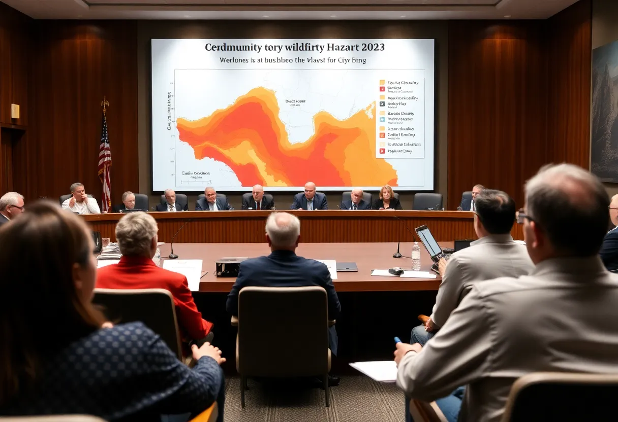
Mission Viejo City Council Approves Updated Wildfire Hazard Map Amid Resident Concerns Over Insurance Rates
The Mission Viejo City Council has approved a new wildfire hazard map, which was received from the California Department of Forestry and Fire Protection (Cal Fire) on March 24. The map classifies various homes in the city into “very high” or “high” wildfire hazard zones. The decision follows extensive discussions during a town hall meeting and a workshop on property insurance, where residents voiced their concerns about the potential impact of the map on fire insurance rates.
Residents, especially those residing near the Wilderness Glen area, referred to as the “volcano” or “bullseye,” have expressed skepticism regarding the risk designations outlined in the map. Many community members are frustrated by rising fire insurance costs and the risk of losing coverage altogether, particularly following the devastating Eaton and Palisades fires.
During the city council meeting, it was noted by council members that insurance companies do not base their rates on Cal Fire maps, leaving residents uncertain about how the new hazard map will affect local insurance costs. Councilmember Trish Kelley highlighted her personal experience, noting that her fire insurance rates had doubled, and she inquired whether mitigation efforts in Wilderness Glen could alter risk designations before the next update of the map in five years. However, Orange County Fire Authority Division Chief Cheyne Maule confirmed that current risk mitigation initiatives would not lead to changes in the map’s hazard designations.
Despite the objections and concerns from residents, the council voted unanimously in favor of adopting the map. This decision reflects the mandatory nature of adopting Cal Fire maps; cities are not allowed to modify the risk designations but can provide feedback. The Deputy City Planning Manager emphasized the importance of these maps for local and state fire planning, which play a crucial role in safeguarding lives and infrastructure.
Called to action by the rising fire dangers in the region, Mission Viejo is one of 16 cities in Orange County identified with areas of very high wildfire hazard. To address the ongoing threat of wildfires, the city is focusing on improving preparedness and community resilience through discussions on fire prevention strategies. Plans include incorporating innovative wildlife mitigation strategies, such as the use of goats for vegetation management, and benefiting from a $2 million grant provided by Cal Fire for fire mitigation projects.
Although the risks reflected in the updated hazard zone map correspond to an increasing scientific understanding of fire threats, residents have been encouraged to take proactive measures. These measures include brush removal and home hardening, which may qualify households for potential discounts on their insurance policies. Furthermore, Mayor Bob Ruesch mentioned that the California Department of Insurance is currently reviewing home hardening efforts, which could potentially enable homeowners to obtain lower insurance rates.
In summary, while the Mission Viejo City Council’s decision to adopt the updated wildfire hazard map is essential for state and local safety protocols, it has fueled ongoing community concerns regarding fire insurance expenses and the accuracy of risk assessments. As residents navigate the implications of these designations, the city’s emphasis on fire preparedness and mitigation efforts remains critical in addressing the threats posed by wildfires.
Deeper Dive: News & Info About This Topic
HERE Resources
California Grapples with Increased Fire Risk
Southern California Faces Significant Fire Hazard Zone Increase
San Jose Chamber of Commerce Aids in Wildfire Recovery
Ontario Named Most Polluted City in the U.S.
Big Changes Coming to Wildfire Risks in California
Los Angeles Wildfires Drive Urgent Rebuilding Discussions
Additional Resources
- Los Angeles Times: Mission Viejo Adopts State Fire Hazard Map
- Wikipedia: Wildfire
- Orange County Business Journal: The Fire Moat Rancho Mission Viejo
- Encyclopedia Britannica: Wildfire
- Patch: What to Know About Your Home Insurance Policy
- Google Search: Wildfire Insurance
- CBS News: State Blocks Insurance Companies After Wildfires
- Google Scholar: Wildfire Risk Management
- Laguna Beach Independent: Supervisor Katrina Foley Updates on Public Safety
- Google News: Fire Hazard Maps